Search
Effort
UB 88 was considered by some to be the most elusive
shipwreck off of Southern California. She had remained
undiscovered for more than 80 years somewhere on the bottom
of the Catalina Channel. On July 9, 2003, utilizing
high-resolution digital imagery provided by the U.S.
Geological Survey, the wreck of UB 88 was located in deep
water southeast of the Los Angeles Harbor lighthouse.
As a sport fisherman I learned a long time ago that the key
to catching fish was to fish where the fish are. Marine
life is attracted to underwater structure, whether natural
or artificial, as it provides the basis for a food chain,
and learning where these “spots” are could
greatly enhance my success on the water. Over the years I
have collected a large database of fishing spots. Natural
rocks, reefs, and hard bottom areas, as well as artificial
reefs and shipwrecks.
In 1989 I purchased a book about Southern California
shipwrecks. This is the first time I had read about the UB
88. I was fascinated by this. An actual WWI German U-boat a
short distance off of Los Angeles! I had never heard of
such a thing. Amazingly, according to the book no one has
been able to find it.
But I have heard stories over the years about people that
supposedly know where it is. One specific story comes to
mind. I had read an article about fishing Southern
California wrecks in a nationally published sport-fishing
magazine. The article was written by a local fisherman (who
shall remain nameless). He stated that the submarine sank
in 120 feet of water, which I know now is incorrect. He
also said “The UB 88 has yet to be located by anyone
– except me.” He concluded by saying “By
the way, I would give up my wife before divulging the
location of the UB 88!” Pretty bold statements I
thought. A year or two later I happened to see this same
writer walking the isles of a local fishing tackle and boat
show. I stopped him specifically to ask him about the UB
88. At the time I thought he might really know where it is.
I didn’t ask him to divulge the location, I just
wanted to know "how" he was so certain that it was really
the UB 88. Did he send down a diver or a video camera or
what? Well he couldn’t give me an answer to that
question, but he still insisted that he knew it's location.
I began my research by obtaining the logbooks of the three
Navy ships involved in the sinking on January 3, 1921. I
requested the logbooks of the Pocomoke, Wickes, and New
Mexico from the U.S. National Archives. Unfortunately,
these reports are vague and conflicting regarding the exact
location of the wreck. This is probably one reason why it
has been so difficult to locate. I was able to come up with
a broad search area that I believed contained the
submarine.
In 1999 I had read about the work that the U. S. Geological
Survey (USGS) had been doing mapping the waters off of Long
Beach, CA. They had been using some very sophisticated
multibeam sonar equipment to generate high-resolution 3D
images of the seafloor. The work they have done is nothing
short of spectacular!
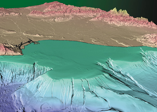
3D
perspective view of the Long Beach Shelf. This area was
mapped by the U.S. Geological Survey in 1996 and 1999 with
state of the art multibeam sonar. Image provided by the
USGS.
I contacted, Jim Gardner, Chief Scientist and head of the
USGS Pacific Seafloor Mapping Project to learn more about
what they were doing and to see if any of their data was
available to the public. As it would turn out, the data
would be made available but it wasn't ready yet.
Fortunately the data was available by the time I started
the search for the UB 88. I found out that obtaining the
data would be the easy part. It’s posted right on
their website. The hard part would be the analysis. The
software needed to view and query this data is called a
Geographic Information System (GIS). The best GIS software
available is ArcGIS by ESRI. ArcGIS and the necessary
extensions carried a handsome price tag. This software has
a steep learning curve and is not easily mastered.
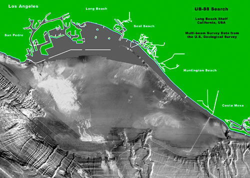
Our
search map of the area off of Long Beach, California. Image
by Gary Fabian. Survey data provide by the USGS.
Having learned the software well enough for my needs, I
proceeded to identify the GPS positions of any targets that
fell within the search area and made a list of their
coordinates. The plan would be to visit each site using a
Lowrance recording sonar. The recording sonar would become
very useful as I could log all of my trips and review the
sonar records later at home on my PC. After identification
of a valid target of some relief, we would send down a
tethered video camera to see what was there.
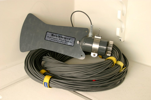
Our
tethered SeaViewer drop camera with 500 feet of cable. This
little camera enabled us to examine many underwater targets
very quickly and avoid the time consuming task of putting a
diver in the water. The plastic fin mounted on the back of
the housing keeps the camera pointed in the direction of
drift. Simple and effective.
We’ve been actively searching for the wreck on a
weekend basis for about fourteen months. Not every weekend.
Sometimes we would go several weeks without going out on
the boat. It’s been such an obsession with me that I
haven’t even done much fishing during this time.
Over two dozen targets were examined before finding the
sunken U-boat. Almost every spot we looked at was a pile of
rocks. These rock piles likely fell from rock barges as
they were brought over from Catalina Island to be used for
various building projects. The biggest being the
construction of the Federal Breakwater protecting Los
Angeles and Long Beach Harbors. Every rock pile was teaming
with life. Clouds of rockfish were on every one.
Unfortunately (fortunately for the rockfish), all these
spots are beyond the present legal depth limit for the take
of rockfish.
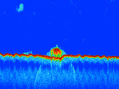
The
first look at UB 88 on the vertical sonar. This image is a
cross sectional profile of the U-boat resting on the bottom
of the Catalina Channel as the survey vessel passed
overhead. The dark red line represents the seabed. The
large red target is the submarine. The boomerang shape that
appears seemingly below the seabed is actually a phenomenon
that occurs from side lobes of the sonar beam recording the
target before the survey vessel arrives and after it passes
overhead.
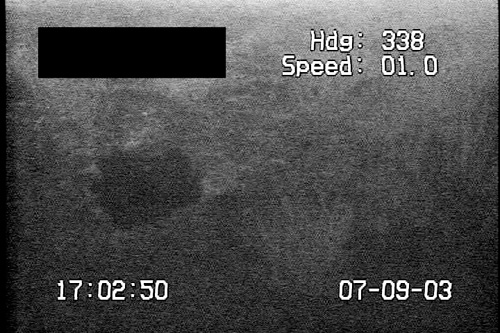
One
of the first images recorded of UB 88. Our video camera
captured this image on July 9, 2003. The black area is
masking the GPS location of the wreck. Note the large hole
from a 4" round fired from USS Wickes on January 3, 1921.
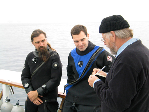
Kendall Raine and John Walker discussing their dive plan
aboard the SUNDIVER.
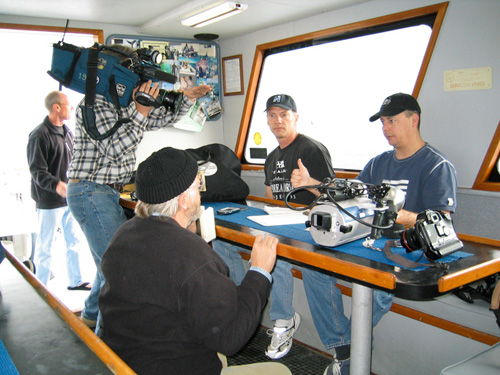
Fred Colburn and Scott Brooks answering questions for Los
Angeles Times reporter.
During the search phase the team consisted only of myself
and Capt. Ray. After locating the wreck we needed to find a
couple of trustworthy divers to round out the team.
Considering the depth of the wreck we couldn’t get
just anybody. This is entirely Ray’s department and
he knew immediately who to contact to do this job right.
Ray invited local technical divers, Kendall Raine and John
Walker. Ray knew Kendall and John from the local dive
community and had worked with both on previous trips to
locate the submarine. Both had extensive deep wreck and
cave diving experience using mixed gases. With thousands of
dives a piece including such wrecks as the SS Andrea Doria,
USS Monitor, USS Wilkes Barre and the Civil War-era gold
ship SS Brother Jonathan. Divers Scott Brooks and Fred
Colburn would later join our team on subsequent dives to
the UB 88. I'm very grateful for everyone's assistance in
documenting this small piece of California's maritime
history. It couldn't have been done without their help.
-Gary Fabian